As a government officer in Meteorological, I must concern in weather activities. Not only from observation whit many tool such as thermometer or barometer, but also from computerize technology. You can use remote sensing to observ the atmosfer, then you can reanalysis to make some information of weather that usefull for people. Today I want to learn you how to make some analysis with satellite imagery From Alabama northeastward into New York is a region of deep convective clouds that appear bright white in both pictures. Because of their higher cloud tops, these clouds are bright white in both images because of their high reflectivity and extremely cold cloud top temperatures. The clouds in Canada probably high thinner cirrus and cirrostratus clouds. They have lower reflectivities and therefore appear somewhat darker in the visible image (a) but because of their higher altitudes and colder cloud tops, they appear bright white in the infrared image (b).  The first way to analysis image satellite is we must have some image. You can use image from data format JPEG, raw format, or other. But I am only explain the data from JPEG. As your consider the weather satellite specially from Geostationary Satellite have 3 channel that common to analysis. There are infrared, water vapour, and visible.
If you live in Asia or Australia, you must get data from MTSAT or FengYun because only 2 this sattelite that cover your region. If you live in america, you can choose GOES Imagery. To download data from MTSAT you can go to www.jma.go.jp and if you want to see imagery from fengyun you can go to www.app.nea.gov.sg there you can download the IR, WV or VIS the inisial from the chanell.
Visible satellite images are photographs of the earth that provide information about cloud cover. Areas of white indicate clouds while shades of gray indicate generally clear skies. Visible images represent the amount of sunlight being scattered back into space by the clouds, aerosols, atmospheric gases, and the Earth's surface. Thicker clouds have a higher reflectivity (or albedo) and appear brighter than thinner clouds on a visible image. However, it is difficult to distinguish among low, middle, and high level clouds in a visible satellite image, since they can all have a similar albedo and for this distinction, infrared satellite images are useful.
Infrared satellite measurements are related to the brightness temperature. For an infrared picture, warmer objects appear darker than colder objects. Since temperature in the troposphere decreases with height, high level clouds are colder than low level clouds.
Images (a) and (b) are examples of visible and infrared satellite images respectively (valid for the same time). 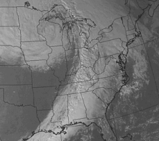
Visible images measure scattered light and the example here depicts a wide line of clouds stretching across the southeastern United States and then northward into Ontario and Quebec. 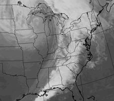
In contrast, are related to brightness. Therefore, the clouds over Louisiana, Mississippi, and western Tennessee in image (a) appear gray in the infrared image (b) because of they are lower and have relatively warm cloud tops. The warmer the temperature, the lower the clouds, the darker the color.  Color enhancement is a procedure where specified levels of energy -- in this example, infrared energy -- are given a specific color. this makes locations with the desired energies easier to locate. Shades of yellow and orange represent infrared energy emissions consistent with strong thunderstorms. This is because infrared energy is proportional to brightness temperature, and the highest cloud tops are colder than those at lower altitudes (the highest cloud tops are typically associated with the strongest thunderstorms).
Water vapor images are useful for pointing out regions of moist and dry air, which also provides information about the swirling middle tropospheric wind patterns and jet streams
Darker colors indicate drier air while the brighter the shade of white, the more moisture in the air. In the image above, very dry air was present from Oklahoma into Illinois (indicated by the dark colors). Bright white plumes stretching from Missouri to South Carolina indicate the very moist air associated with thunderstorms occurring in the area
Tuesday, 24 June 2008
Globe Weather from Satellite
Posted by andersen at 09:58
Labels: Remote Sensing
